During the last ice age, the Tri-Cities experienced some of the largest fresh water floods known to have happened anywhere on the plant. This is an incredible part of the geological history that shaped our area. This page features some key historical elements that are present on the Interpretive trails
How Many Floods Were There?
The quiet water areas in the floods are the key to determining the number of Ice Age Floods. In this short 4 minute video you will visit some of the key slackwater (slow water) sites surrounding the Tri-Cities (within Lake Lewis) and count the number of Ice Age Floods by counting the number of lake bed deposits (rhythmites).
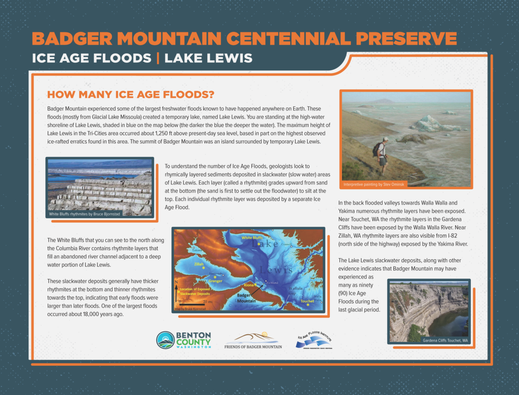
One interesting observation geologist have made from the slackwater deposits is they generally have thicker rhythmites (thicker layers) at the bottom and thinner rhythmites towards the top, indicating that early floods were larger than later floods. In general, the deeper the flood water (larger the flood) and the deeper the flood water the more material available in the water column to create the lake bed deposit (rhythmite). One of the largest Ice Age Floods occurred about 18,000 years ago. See Gardena Cliffs photo on bottom right of the Lake Lewis Interpretive sign (the rhythmite layers are clearly thicker at the bottom of the cliff). Again, each individual rhythmite layer was deposited by a separate Ice Age Flood.
For more information, click the image at the right (a larger view will open)
What was the Water Source?
The mysterious water source (that Bretz did not find in eastern Washington) was located in western Montana (Glacial Lake Missoula). During the last Ice Age, a >2000-foot high ice dam blocking the Clark Fork River drainage and resulting in the formation of Glacial Lake Missoula (at its maximum size was 200 miles long and >2000 feet deep). Cataclysmic failure of this ice dam resulted in the sudden release of the Glacial Lake Missoula and the ensuing Ice Age Floods.
After each outburst flood, the glacial ice lobes continued to advance southward into the breach, re-forming the ice dam and then forming a new Glacial Lake Missoula; only to fail again producing a new Ice Age Flood with each ice-dam failure.
New Age Dating helps define the path of the Ice Age Floods
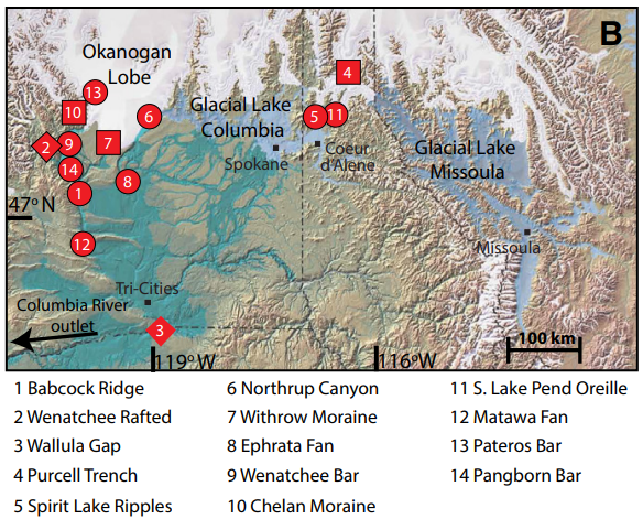
Age dating erratics left behind by these floods helps to understanding the flood history, the sequence to the errosion of the Channeled Scabland, and relationships to the Cordilleran Ice Sheet (CIS). Based on age dating erratics above Wenatchee WA, one of the largest floods occurred about 18,000 years ago. Age dating study also shows the Okanogan lobe blocked the Columbia River valley about 15,000 years ago and diverted the majority of Missoula floods through the Channeled Scabland. Finally, age dating study shows the youngest flood occured about 14,000 years ago from Glacial Lake Columbia, that persisted for a few centuries after the last Missoula flood.
Andrea Balbas’s age dating sample locations are shown in the map below.

Erratics
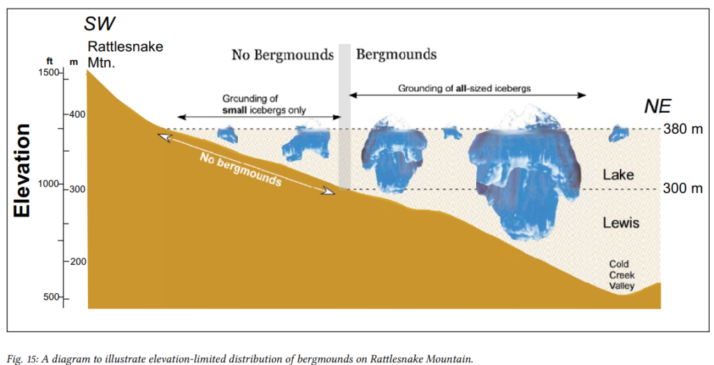
There are three types of ice-rafted debris: 1) an isolated erratic consisting of a solitary boulder; 2) erratic clusters consisting of a close grouping of erratics (there are 22 erratics in the cluster near the Canyon Trail); and 3) bergmounds consisting of distinct, low-relief mounds containing ice-rafted debris.
Highest Concentration of Erratics in Eastern Washington:
Ice-rafted debris from the breakup of ice-dammed glacial lake Missoula is common in slackwater areas along the 700 mile route of the Ice Age Floods from Missoula Montana, past Spokane, through the Tri-Cities and down the Columbia River Gorge to the Pacific Ocean. The eastern slope of Rattlesnake Mountain has an exceptionally high concentration of ice-rafted debris located midway along the floods’ path. In the Tri-Cities area floodwaters temporarily rose to 1250 foot elevation (forming short-lived Lake Lewis) behind the first substantial hydraulic constriction for the outburst floods near Wallula Gap. Within the 30 square mile Rattlesnake Mountain study area geologist Bruce Bjornstad found more than 2,100 erratic isolates and clusters, as well as bergmounds were recorded. In the study area, three quarters of erratic boulders are of a granitic composition. Other exotic (non-native) rock types include Proterozoic quartzite and argillite as well as gneiss, diorite, schist and gabbro, all once in direct contact with the Cordilleran Ice Sheet to the north. In the study area, most ice-rafted debris is concentrated between 650 and 1000 foot elevation. Far fewer erratics and bergmounds lie above 1000 foot elevation, because larger deep-rooted icebergs were forced to ground farther away from the ancient shorelines of temporary Lake Lewis (SEE Figure above). As floodwaters moved across the uneven surface of Rattlesnake Mountain, many erratic-bearing icebergs were captured by pre-existing gullies that trend crosswise to flood flow. See links below for more information.
Based on Bruce Bjornstad, et all 2014 article “Ice-Rafted Erratics and Bergmounds from Pleistocene Outburst Floods, Rattlesnake Mountain, Washington, USA, published by E & G Quaternary Science Journal.


